

So in the past several years I have seen more advancement from creating 3d models from photos. So let's say we want the coast line at pebble or cypress could we just find a bunch of photos online and if we could create a model from those photos would it be practice to import that as a mesh into unity/CF? Sorry if this does not make sense.

3d from photos
Started by
scottpussehl
, Oct 09 2014 12:14 PM
4 replies to this topic
#1

scottpussehl
-
- Members
-

- 49 posts
Advanced Member
- LocationMichigan, USA
Posted 09 October 2014 - 12:14 PM
#2
Dazmaniac
-

- Members
-
- 6,941 posts
Rock. Loud and Heavy
- LocationEngland, UK
Posted 09 October 2014 - 04:24 PM
S,
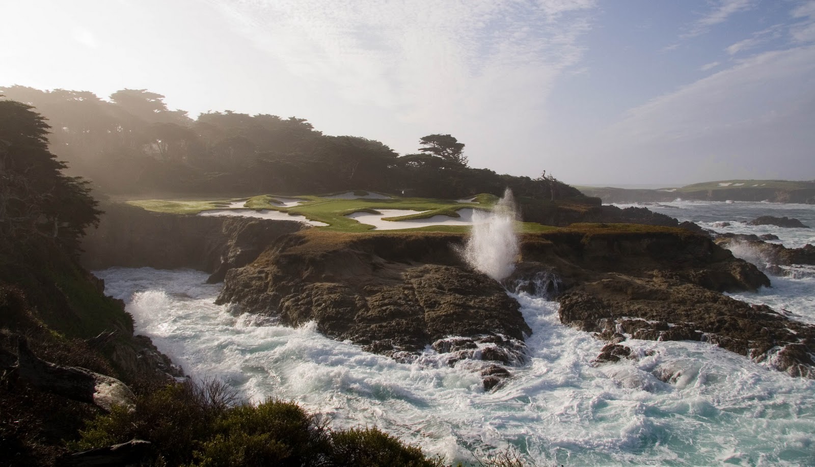
Yes, as I think what you are getting at is importing a heightmap in to your Unity project which would have elevation data to the nearest whatever metre, depending where in the world he data is being gathered (as some areas are more detailed than others).
This then gives you a good starting point and the elevations would just need fine tuning and smoothing and then the overhead texture map laid on top of it and then you have your heightmap and terrain laid out, then you fire up Course Forge and trace out the course and you're on your way to creating something like this...

#3
scottpussehl
-
- Members
-
- 49 posts
Advanced Member
- LocationMichigan, USA
Posted 09 October 2014 - 08:25 PM
Sorta of check out Autodesk 123D
It operates by usings 30-100+ photos and creating a point cloud of an area
in essence yes it could be used as a height map, but I think it could be more accurate as a actual model you would pull in
I got to say what you did with your cliff in the photo above looks great but still not quite as rocky and eratic as the below photo
I know i am expected way to good of results
#4
Dazmaniac
-
- Members
-
- 6,941 posts
Rock. Loud and Heavy
- LocationEngland, UK
Posted 09 October 2014 - 09:28 PM
S,
It is not my work, it is just a pic from the Pebble Beach flyover that PP did (I should have really put that in the original post).
Such recreations of your pic of Cypress Point maybe possible, with the detailed outcrops of rocks etc. but you are at the mercy of Unity 3D and the detailing that it allows when applying textures to elevations and such.

#5
shimonko
-

- Members
-
- 1,718 posts
Advanced Member
Posted 10 October 2014 - 01:44 AM
So in the past several years I have seen more advancement from creating 3d models from photos. So let's say we want the coast line at pebble or cypress could we just find a bunch of photos online and if we could create a model from those photos would it be practice to import that as a mesh into unity/CF? Sorry if this does not make sense.
So this is Photogrammetry and you're right, it's getting very good. Google Earth now use it to create their 3 dimensional world. But it can't be done very well using random photos from online as it's very much dependent on knowing the shooting characteristics (location and equipment) and having tons of photos. Plus it relies on distinct features, like buildings. Subtle undulations in greens and fairways can't be picked up so other technologies like LiDAR are used with it.
I don't feel it has much merit for golf sims. We need to see grass from a few feet away so it needs detail. To get such detail from photos there would be literally millions of them and current graphics cards could never handle it.
I suspect WGT use photogrammetry for the working out where to insert the player character in the photo, but as you may have seen, WGT is graphically a slideshow rather than a truly 3d game. I also suspect they'd use LiDAR and green scans for generating the underlying terrain for their physics.


1 user(s) are reading this topic
0 members, 1 guests, 0 anonymous users


