Jump to content


Photo

Terrain Importer Trial


  • Please log in to reply
32 replies to this topic

#1 highfade

highfade

    Advanced Member

  • Members
  • PipPipPip
  • 1,749 posts
  • LocationSouth Africa

Posted 07 June 2013 - 08:06 AM

Andrew

Thanks for this. I've only tried the crz file import so far and it seems to work as it should. I suppose the trial is just to test as with the low resolution it's useless. Will give more feedback on some other tests.

Feedback:

It doesn't create a desktop icon.

With the Bing map export it only creates a raw file but no option to save the jpg?

Adriaan


Intel Core i5-6600 CPU 3.3 GHz       Geforce GTX 1060        16GB  RAM       Windows 10 64 bit

Hazyview  (600m above sea level)    --   Nautilus Bay  (Revamp done)  --  Cape Fear  (TGC  adaptation)  --  Aloe Ridge  --  Nahoon Reef GC  --  Chambers Bay 

Abel's Crossing  --  Solitude Links GC


#2 Andrew

Andrew

    Administrator

  • Administrators
  • 2,524 posts
  • LocationUSA

Posted 07 June 2013 - 11:15 AM

I made a boo boo and forgot when I uploaded the new version to tie it to the store so for a while it was downloadable as a trial.  I have turned that off and we will be releasing it imminently with the ability to get a license key one way or another.

Correct on the desktop icon, that is by design, I hate stuff that clutters up my desktop and I am more than capable of putting stuff there I want, so I just put a shortcut in the start menu.  On the bing maps because we use Async code the heightmap completes before the image is downloaded in the trial version and the dialog box for the heightmap is overlayed on top of the image one.  I think if you move it it will be there.  This is a problem we have been able to replicate and are working on a fix.  Problem does not exist outside of trial mode.

Thanks for your patience Andrew


#3 Brucey Mc

Brucey Mc

    Advanced Member

  • Members
  • PipPipPip
  • 438 posts
  • LocationTeesside, UK #UTB

Posted 07 June 2013 - 01:57 PM

Can't wait!


#4 Davefevs

Davefevs

    Advanced Member

  • Members
  • PipPipPip
  • 454 posts
  • LocationBristol

Posted 07 June 2013 - 04:45 PM

Is anyone else able to trial / test it at present, or are we waiting for Andrew to upload again?

#5 rwmorey

rwmorey

    Advanced Member

  • Members
  • PipPipPip
  • 37 posts

Posted 07 June 2013 - 05:13 PM

I'm still waiting for it to be available. I tried to "buy" it and was told I didn't have access.


#6 Davefevs

Davefevs

    Advanced Member

  • Members
  • PipPipPip
  • 454 posts
  • LocationBristol

Posted 07 June 2013 - 05:25 PM

Me too

#7 HalkeFralg

HalkeFralg

    Member

  • Members
  • PipPip
  • 23 posts

Posted 07 June 2013 - 08:29 PM

Waiting patiently...


#8 highfade

highfade

    Advanced Member

  • Members
  • PipPipPip
  • 1,749 posts
  • LocationSouth Africa

Posted 09 June 2013 - 04:46 PM

Andrew, is it possible to have a more precise zooming option for the Bing maps. It's always too close or too far. :huh:


Intel Core i5-6600 CPU 3.3 GHz       Geforce GTX 1060        16GB  RAM       Windows 10 64 bit

Hazyview  (600m above sea level)    --   Nautilus Bay  (Revamp done)  --  Cape Fear  (TGC  adaptation)  --  Aloe Ridge  --  Nahoon Reef GC  --  Chambers Bay 

Abel's Crossing  --  Solitude Links GC


#9 Dazmaniac

Dazmaniac

    Rock. Loud and Heavy

  • Members
  • PipPipPip
  • 6,941 posts
  • LocationEngland, UK

Posted 09 June 2013 - 08:15 PM

Andrew, is it possible to have a more precise zooming option for the Bing maps. It's always too close or too far. :huh:


I think that's just a trait of BING maps and not so much the CCT.


I appreciate what you mean though, as when zooming on the overhead of my home course, at one point it is just too far away, but then move up one on the slider and it gets too close that parts of the course are missing, lol. It appears the zoom level BING uses is in quite large chunks.


;)


#10 oZZeus

oZZeus

    Newbie

  • Members
  • Pip
  • 7 posts
  • LocationQueensland, Australia

Posted 09 June 2013 - 08:32 PM

I managed to "sneak" in the download while it was open too. I have had exactly the same experience as Adriaan. Had a couple of other problems, but went back and watched the videos and all was well. Currently working on a test project (new real course that is currently under construction) on Unity. Terrain modelling is quite straightforward and I'm using a contour plan /course layout as the base image/overlay.


#11 garynorman

garynorman

    Advanced Member

  • Members
  • PipPipPip
  • 481 posts
  • LocationBedfordshire, England

Posted 09 June 2013 - 08:36 PM

It may just be me, but I have imported a course from the US national map viewer and I'm finding that the smallest brush size in the terrain tools is still the size of one of the bunkers making it impossible to actually do any work...


Is anyone else experiencing this?


#12 Davefevs

Davefevs

    Advanced Member

  • Members
  • PipPipPip
  • 454 posts
  • LocationBristol

Posted 09 June 2013 - 08:57 PM

I'm getting jealous, having missed the window.

@gary - I'm guessing you are doing this in Unity....and hoping that CF will allow us the granularity of brushes we need?

All - was it easy to import using the TI?

#13 TimBoch

TimBoch

    Advanced Member

  • Members
  • PipPipPip
  • 359 posts
  • LocationFarmington, MN

Posted 10 June 2013 - 03:30 AM

It may just be me, but I have imported a course from the US national map viewer and I'm finding that the smallest brush size in the terrain tools is still the size of one of the bunkers making it impossible to actually do any work...


Is anyone else experiencing this?

I played around with Unity to do some  elevation painting and found it very time consuming and not even close to what you saw in MJs video. Since he was using Course Forge, I am thinking that is designed much more for course designing.  The way Unity is right now, reminds me of trying to design a course using the old SimGolf game. Very time consuming to elevate and make even close to realistic looking for real courses.  APCD was a lot to wrap my mind around when I first started. In fact, took me almost 6 years to think I made a course even worthy to be a beta.  Took another few years to learn how seam blend.  Then things started clicking and I spent probably thousands of hours making some mediocre courses.  I am hopeful for the day CF comes out and look forward to importing and updating my APCD designs.  Would love to see moving waterfalls on Infamous Golf Course.  Just hope Unity and CF will allow what APCD surprisingly did and Links allowed to be played on that strangest of courses.


  • garynorman likes this
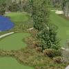
Course Forge Courses in various stages of design: Dwan Golf Club, Hyland Greens, Faribault CC, Desert Valley CC/ Woodland Trail(fictional), Infamous Golf Course (fantasy)
Links 2003 Designs: Dwan Golf Club, Infamous Golf Course, Hazeltine National Golf Club (assistant designer), Woodland Trail/Desert Valley CC , Faribault CC (beta), Hyland Greens (beta), Double Eagle (beta), King's Walk (beta), Interlachen CC (still in planning)
Intel Core i7-4710HQ 2.5GHz
  • Microsoft Windows 8.1 64-bit
  • 16GB DDR3L RAM
  • 750GB 7,200RPM Hard Drive
  • NVIDIA GeForce GTX 850M

#14 oZZeus

oZZeus

    Newbie

  • Members
  • Pip
  • 7 posts
  • LocationQueensland, Australia

Posted 10 June 2013 - 04:12 AM

It may just be me, but I have imported a course from the US national map viewer and I'm finding that the smallest brush size in the terrain tools is still the size of one of the bunkers making it impossible to actually do any work...


Is anyone else experiencing this?

Absolutely!! It is taking some time to develop the right techniques - reuires high resolution, playing with brush sizes, etc.

I presume you mean edges and shapes like this... capture-1


but they end up like this (capture-2) and will just need some planting to disguise any messy bits.


Cheers


Scott

Attached Files


#15 Mick-S

Mick-S

    Advanced Member

  • Members
  • PipPipPip
  • 397 posts
  • LocationDevon.u.k / born London

Posted 10 June 2013 - 12:51 PM

so am I correct in thinking that the few people that were online at the right time were able to download.


#16 HalkeFralg

HalkeFralg

    Member

  • Members
  • PipPip
  • 23 posts

Posted 10 June 2013 - 02:56 PM

so am I correct in thinking that the few people that were online at the right time were able to download.

Sounds like it. A day late and a dollar short...the story of my life!


#17 Mick-S

Mick-S

    Advanced Member

  • Members
  • PipPipPip
  • 397 posts
  • LocationDevon.u.k / born London

Posted 10 June 2013 - 03:16 PM

Sounds like it. A day late and a dollar short...the story of my life!

wife has gone to her mothers for several days, all that time alone to play with it and I can`t get it :angry:,

typical.


#18 Mike Jones

Mike Jones

    Advanced Member

  • Administrators
  • 6,159 posts

Posted 12 June 2013 - 10:15 AM

The sweet spot for our golf related purposes in Unity is less than 1 metre per pixel of heightmap to 1 metre of distance on your terrain. Heightmaps in unity can go up to 4096x4096 but the larger the resolution of the heightmap, the more time consuming it is to work on.


We use 2049 heightmaps on pretty much all of our courses and the examples you have seen so far with making holes and bunkers in CourseForge.


When creating a completely new fictional course there is some value in starting out with a very low resolution heightmap in order to make widescale elevation changes and then resizing it in Photoshop or gimp etc to a higher resolution for when you want to work on more detailed areas. You can import and export heightmaps into unity very easily and I'll be doing a tutorial on that at some point.


#19 Brucey Mc

Brucey Mc

    Advanced Member

  • Members
  • PipPipPip
  • 438 posts
  • LocationTeesside, UK #UTB

Posted 12 June 2013 - 11:44 AM

All this kind of feels like turning up for your first driving lesson and discovering that you won't be going near a car until lesson two. Lets hope lesson two isn't far away, this boy racer is raring to go.

#20 Acrilix

Acrilix

    Advanced Member

  • Members
  • PipPipPip
  • 1,832 posts
  • LocationBedford, UK

Posted 12 June 2013 - 12:58 PM

From everything I've seen and read so far, it seems that there is going to be a lot more work needed for some of us than the original hype led us to believe. For people with available data to download, things may be a good deal easier, but for the rest of us it may not be as simple as it first appeared. The additional need to purchase assets to achieve professional looking results like the water effects in the PG video, is also beginning to drain my enthusiasm again. :mellow:


life ................... don't talk to me about life ................


1 user(s) are reading this topic

0 members, 1 guests, 0 anonymous users