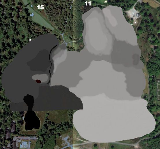
not being able to get a heightmap for a course I want to design, decided to attempt to create my own. think it might take a while and as I`m 67 hope I survive long enough to finish it, but joking aside a ? for any one who has CF and has designed a course, is it worth the hassle of creating your own heightmap, and being my 1st not sure how much difference the shades from white to black make the actual height, anyone who has done this any help much appreciated.

HeightMaps
#1

Posted 04 July 2015 - 06:01 PM
#2

Posted 04 July 2015 - 06:14 PM
Right up my alley.
You can make your heightmap from all white to total black - upon importing it, you will get to set the height of your terrain. Black will be at 0 and white at the selected terrain map.
Your heightmap needs to be in RAW format and in grayscale color mode!
For it to match your design, you need to flip it vertically. Heightmaps are pushing from the bottom up, textures are projected from the top down, so flip it to get a match.
There is no point in wasting too much time on a precise height map imo. Just let your first one contain all major elevations, mounds and valleys and slopes, very approximately. The detail work will be done with Unity terrain sculpting, the height map just is a first draft. In my projects I quickly made major changes to the original height map, because out in Unity you get a much better impression about proportions and meaningful sculpting than in a black and white graphics file.
If you feel adventurous or can't be bothered, go ahead without one.
>>>>>>> Ka-Boom!
• Mulligan Municipal • Willow Heath • Pommeroy • Karen • Five Sisters • Xaxnax Borealis • Aroha • Prison Puttˆ
• The Upchuck • The Shogun • Black Swan (•)
<<<<<
#3

Posted 04 July 2015 - 06:21 PM
K11 this sounds as though heightmaps for real courses are going to be pretty useless???. Know how you feel Mick - I am 68 later this month and my brain cell(s) is/are not getting any younger. Hoping Course Forge will be released before I am 69 ![]()
#4

Posted 04 July 2015 - 07:12 PM
Sounds like, Jimbo63. Sorry, but Mick mentioned creating a fictional course and my answers were all about this speciality.
I could never possibly, and never ever will, discuss anything pertaining to boring, unessential, irrelevant courses real courses
>>>>>>> Ka-Boom!
• Mulligan Municipal • Willow Heath • Pommeroy • Karen • Five Sisters • Xaxnax Borealis • Aroha • Prison Puttˆ
• The Upchuck • The Shogun • Black Swan (•)
<<<<<
#6

Posted 04 July 2015 - 08:32 PM
Good thinking about the water.
Yes, roughly like that. Try to make softer, more blurry borders, perhaps, because otherwise you get very vertical steps. But a very basic height map like that will help you a lot to start working on the "lay of the land".
>>>>>>> Ka-Boom!
• Mulligan Municipal • Willow Heath • Pommeroy • Karen • Five Sisters • Xaxnax Borealis • Aroha • Prison Puttˆ
• The Upchuck • The Shogun • Black Swan (•)
<<<<<
#7

Posted 04 July 2015 - 08:39 PM
I was going to add a blur all over once finished or something like that, will play around with it to get the desired effect on the borders, but thanks for the tips, if the elevations are to steep can always go back in and make the grey tones closer, hopefully.
just one other ? , before saving the .raw file, how many alpha channels should there be.
#8

Posted 04 July 2015 - 11:05 PM
It's likely that there is at least 30 metre elevation data available for your course, not great but it'll greatly reduce the effort it takes. I'm away for two days but either post your course and someone may find you one, or PM if you'd rather keep it private.
- shimonko likes this
#9

Posted 04 July 2015 - 11:23 PM
Thanks shimonko most helpfull.
0 user(s) are reading this topic
0 members, 0 guests, 0 anonymous users


