Jump to content


Photo

Arrowhead


  • Please log in to reply
17 replies to this topic

#1 nstone73

nstone73

    Advanced Member

  • Members
  • PipPipPip
  • 146 posts
  • LocationDenver CO

Posted 04 February 2017 - 03:33 AM

Got some really nice base data from Larry over at OGT to try my hand at a real course....Arrowhead G.C. in Colorado. Some pretty impressive elevation changes on this course...I think the landing area at the 10th here is about 70ft below the tee box.


I've laid out the basic hole shapes and it actually plays pretty nice without any adjustment. That's not to say I've not got plenty of smoothing to carry out.


5471b8b9f9.jpg


One thing I've noticed from the overhead Larry gave me, and from Google Maps is that the fairways here go up to the green, but not around them. Has anyone dealt with that? I was thinking either put a sliver of fairway around the green or put it up as close to the green as possible.


Plenty of houses around the course, so looking forward to utilizing DPRobert's house builder package.


Any tips out there on turning around a real course?


Cheers,

Neil


#2 Larrykuh

Larrykuh

    Advanced Member

  • Members
  • PipPipPip
  • 244 posts

Posted 04 February 2017 - 04:42 AM

I was just telling pingzing about the three Denver courses and mentioned you were doing Arrowhead. Looking good!! The lidar should be excellent as I believe it is 50cm. Even though I'm certainly not an expert, I would surround the greens with what you call a sliver of fairway.


#3 M Rose

M Rose

    Advanced Member

  • Members
  • PipPipPip
  • 1,918 posts
  • LocationMelbourne, Australia

Posted 04 February 2017 - 05:02 AM

Awesome. I have yet to play this one but it's in my sights.

Cherry Hills is coming along well and is my next priority after Royal Melbourne is finished.

VG2 • PG • 2k21 • 2019 • Links • GBC • JN5


#4 DPRoberts

DPRoberts

    Advanced Member

  • Members
  • PipPipPip
  • 1,610 posts

Posted 04 February 2017 - 05:21 AM

Very nice. Is all the peripheral elevation from Lidar? If so, that's the one thing that's a bear to get correct by hand in Unity. The tools don't allow some of that precise elevation contouring. Just one of the huge pluses of the Lidar builds. You'll have to spend some time on the textures because of stretching over verticals. I recommend the K11 video that's out there on terrain painting elevations.

If you don't take your fairway around the green and try and snug it up to the front, you will have a tiny sliver of rough between the green and fairway. If your blends are small enough, you can make it look reasonable. It's a tough call but going around is probably the least complicated. Decide that early so you don't waste time doing and undoing. It's one of my bad habits.

#5 pingzing

pingzing

    Advanced Member

  • Members
  • PipPipPip
  • 954 posts
  • LocationQld Australia

Posted 04 February 2017 - 05:44 AM

Got some really nice base data from Larry over at OGT to try my hand at a real course....Arrowhead G.C. in Colorado. Some pretty impressive elevation changes on this course...I think the landing area at the 10th here is about 70ft below the tee box.


I've laid out the basic hole shapes and it actually plays pretty nice without any adjustment. That's not to say I've not got plenty of smoothing to carry out.


5471b8b9f9.jpg


One thing I've noticed from the overhead Larry gave me, and from Google Maps is that the fairways here go up to the green, but not around them. Has anyone dealt with that? I was thinking either put a sliver of fairway around the green or put it up as close to the green as possible.


Plenty of houses around the course, so looking forward to utilizing DPRobert's house builder package.


Any tips out there on turning around a real course?


Cheers,

Neil


Take a Picture, make a poster, This picture is talking to me , visuals, elevations, 


I am sitting up and getting excited at what i see


Thank you neil 


#6 Dazmaniac

Dazmaniac

    Rock. Loud and Heavy

  • Members
  • PipPipPip
  • 6,941 posts
  • LocationEngland, UK

Posted 04 February 2017 - 08:32 PM


5471b8b9f9.jpg


Looks like you're off to a good start. Here's the real life Hole #10


Hole-10.jpg


Good luck with the design sir.


  • RobC likes this

#7 Larrykuh

Larrykuh

    Advanced Member

  • Members
  • PipPipPip
  • 244 posts

Posted 04 February 2017 - 09:09 PM

That lidar view compared to the actual is amazing. The hole I'm anxious to see is 13. Too bad it wasn't around when I lived in Littleton. :(


#8 pingzing

pingzing

    Advanced Member

  • Members
  • PipPipPip
  • 954 posts
  • LocationQld Australia

Posted 05 February 2017 - 08:57 AM

Great find this course, wish i had found it ,so well done , this is the sort of stuff i like, different and interesting, grabs your attention

If you need help with textures for those awesome Rocks ,  thats if you dont how to go go about it. , yell out, i already have some similar but  i can try and Zoom down and make some for you,or someone else here can help. so just reach out for help here as this is going to be a Ripper .


Thanks


  • cajuncapgun likes this

#9 Skunky

Skunky

    Advanced Member

  • Members
  • PipPipPip
  • 373 posts
  • Locationmarble falls tx

Posted 05 February 2017 - 02:35 PM

looks really intresting,the lidar  is so much better than a heightmap.


shadowcreek: tpc avenel:tpc san antonio:valhalla:quail hollow:trump coltsneck:hudson valley:ferry point:bedminster old and new course

Pasatiempo:Kingswood:Carnoustie:Augusta:SandHollow:TPC Summerlin


#10 DPRoberts

DPRoberts

    Advanced Member

  • Members
  • PipPipPip
  • 1,610 posts

Posted 05 February 2017 - 02:54 PM

Quadet63, I think I know what you are trying to say but all terrain contours in Unity are technically represented by heightmaps. Below is for anyone who cares on the explanation.

A heightmap is a greyscale representation that Unity can interpret to generate terrain elevation.

Lidar is one form of data (lidar point cloud) that can be interpreted by programs (ArcGIS, Global Mapper) and a heightmap can be generated/exported. It has varying levels of accuracy, such as 1m or 50cm.

There are other less precise forms such as Arc second data which is where I believe terrain party creates its heightmaps.
  • Skunky likes this

#11 nstone73

nstone73

    Advanced Member

  • Members
  • PipPipPip
  • 146 posts
  • LocationDenver CO

Posted 05 February 2017 - 05:05 PM

Here's a quick look at the 13th....a downhill (80ft) par 3 (170 yards). I think in real life I have about a 50% success rate at hitting this green, I bombed one over the back the first time I played it and duffed one into the trees too.


As mentioned in my initial post, I really just quickly drew the  splines in and have done no manipulation of the terrain and no planting:

75626cf9bb.jpg

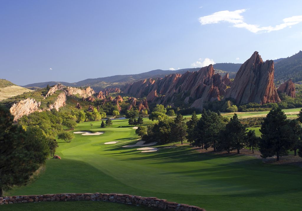
Here's a pic of the real 13th, you can see there is a lot of "junk" between the top tee and the one below (which you can't actually see from the top tee):

757092d590.jpg

...finally, here's an overview from Google Maps of the hole (the tee is in the shadows at the bottom left of the image):

75767923d7.jpg

You can see the rocks look great at a distance, but the vertical stretching mentioned by DPRoberts is evident as you get closer. Any help with textures and applying them would be greatly appreciated, to be honest, that's what severely lacking in my first course (The Cheviot), I think the golf part is fine and I was really happy with the course, but the surrounding environment leaves a lot to be desired. I did sign up to textures.com and downloaded a bunch of textures from there too. I need to find the K11 videos DPRoberts mentions too.


Also, not on this hole, but I guess the same theory regarding a rough spline surrounding a bunker also needs to apply. A lot of the fairway bunkers on this course seem to be half way in the rough and half in the scrub.


Finally, I don't really see any evidence of a first cut of rough to be honest...seems to be fairway (or green) straight to rough. In real life, the rough isn't too severe, more like a first cut...so not really sure what I can tweak or change in CF to replicate that....guessing that's down the line but wanted to throw that out there too. 


I guess after quickly laying out the splines of the course, the hard work starts now.

Cheers,

Neil


#12 bortimus

bortimus

    Advanced Member

  • Members
  • PipPipPip
  • 1,234 posts

Posted 05 February 2017 - 05:09 PM

Love that landscape.  Looks like a really interesting place to play golf! 


#13 nstone73

nstone73

    Advanced Member

  • Members
  • PipPipPip
  • 146 posts
  • LocationDenver CO

Posted 05 February 2017 - 05:20 PM

Love that landscape.  Looks like a really interesting place to play golf! 

It's really cool, I remember playing there once late in the season, there was snow in the shaded areas, which stopped some wild shots going into wilder places....the tee markers had been taken in and they let us play off whatever tees we wanted to. The wildlife is pretty cool too...plenty of deer about, and there's a fox that lives next to that 13th tee.


#14 DPRoberts

DPRoberts

    Advanced Member

  • Members
  • PipPipPip
  • 1,610 posts

Posted 05 February 2017 - 05:32 PM

Here is the K11 video on terrain texturing - produced by Kablammo11, as always his productions are so well done.


I have a fictional course in the queue like many others, Terra Firma, that needed better texturing. I have several Canyon textures that I can PM you but found most on CGTextures.com. The trick, for me, was using a Texture map that was not necessarily the same as the Normal map and terrain paint blending 2-3 textures.


A second option I tried but would reserve recommendation until further experimentation was https://www.assetsto...!/content/23425


Terra Firma concept

WA9gTkA.jpg


You have selected quite a challenge. It should be a joy to work on and you will learn much along the way.


My last hope is that one day we could use ReliefTerrainPack (RTPv3) and get some true AAA finish to these productions. However, I was worried the scripting in that would not jive with CF.


  • nstone73 likes this

#15 Skunky

Skunky

    Advanced Member

  • Members
  • PipPipPip
  • 373 posts
  • Locationmarble falls tx

Posted 05 February 2017 - 05:45 PM

dp , what i should have said was, lidar is so much better to work with than a heightmap.example,when i started valhalla with 1m lidar it was like night and day compared to tpc avenel ,which i had to really munipulate the land.valhalla was so good ,i literally was able to bring in water planes and populate all the lakes and rivers without munipulation. an incredable time saver.


  • DPRoberts likes this

shadowcreek: tpc avenel:tpc san antonio:valhalla:quail hollow:trump coltsneck:hudson valley:ferry point:bedminster old and new course

Pasatiempo:Kingswood:Carnoustie:Augusta:SandHollow:TPC Summerlin


#16 nstone73

nstone73

    Advanced Member

  • Members
  • PipPipPip
  • 146 posts
  • LocationDenver CO

Posted 05 February 2017 - 05:47 PM


You have selected quite a challenge. It should be a joy to work on and you will learn much along the way.


Ha ha...yep, jumping in at the deep end, but when I saw the quality of the data that Larry gave me. Thanks for the link to the video. I'll take a look at that textures website too.


I don't think anyone should expect this to be out in the next couple of months....I'm already guessing I'll have to jump back and forth between this and fictional courses to get my course layout design fix too.


Thanks again,

Neil


#17 DPRoberts

DPRoberts

    Advanced Member

  • Members
  • PipPipPip
  • 1,610 posts

Posted 05 February 2017 - 06:00 PM

dp , what i should have said was, lidar is so much better to work with than a heightmap.example,when i started valhalla with 1m lidar it was like night and day compared to tpc avenel ,which i had to really munipulate the land.valhalla was so good ,i literally was able to bring in water planes and populate all the lakes and rivers without munipulation. an incredable time saver.


Yes, doing 4000000 m^2 worth of terrain work by hand is a daunting task. Really makes you appreciate what some of the guys do on the fictional work and what others did before lidar in attempting true to life creations.

#18 pingzing

pingzing

    Advanced Member

  • Members
  • PipPipPip
  • 954 posts
  • LocationQld Australia

Posted 06 February 2017 - 09:16 AM

The K11 videos for making textures is on this Updated link

 Select More videos at Bottom right and Scroll down on the right until you see the map of Australia, thats Tut 1 to Tut 5

I followed them and wrote down word for word all the steps, really appreciate k11 for This,  if you take the time  you will reap

Goof Luck 


  • nstone73 likes this


0 user(s) are reading this topic

0 members, 0 guests, 0 anonymous users