

I guess the subject says it all really.
I've got something I'm working on hopefully to get in ascii format with a homemade overhead map. I will post some screenshots of progress when it's at a cleaner stage than it currently is.
Bruce

Advanced Member

Posted 01 June 2013 - 06:55 PM
I guess the subject says it all really.
I've got something I'm working on hopefully to get in ascii format with a homemade overhead map. I will post some screenshots of progress when it's at a cleaner stage than it currently is.
Bruce
Rock. Loud and Heavy

Posted 01 June 2013 - 07:55 PM
Never designed anything in APCD.
Just getting my head around the controls of Unity 3D at the minute and learnings the ins and outs of that before the next step of prepping course layout, as I'm going to have a go at recreating my home course.
Also regards Unity, latest version is available to download (660MB) - v 4.1.3

Advanced Member
Posted 01 June 2013 - 08:10 PM
They seem to update Unity fairly often, good job i've got Sky Unlimited broadband! It's 1.1 Gb for the Mac
Advanced Member

Posted 01 June 2013 - 08:35 PM
I think I'm gonna do what Daz is doing and start familiarizing myself with Unity, and then possibly prep everything for my home course. I might even contact them so I can ride around in a cart and take pictures to make sure I have snapshots of each hole to properly recreate it.
TheLighterDark / "William" / University of Arkansas, Fayetteville / 21
Toshiba Satellite S855 / Windows 8 64-bit / Intel Core i7-3630QM CPU @ 2.40GHz / 8.00 GB RAM

"All the world on one arrow..." - Ashe, The Frost Archer, League of Legends.
Member

Posted 01 June 2013 - 11:29 PM
Tinkering with Unity has been all I've done. Really looking forward to Course Forge!
Advanced Member
Posted 02 June 2013 - 12:49 AM
Administrator

Posted 02 June 2013 - 01:54 AM
Member

Posted 02 June 2013 - 03:07 PM
Been working really hard on the converter. Having read previous comments about other more detailed data. I am delighted to say we are very close to getting it working with both ERDAS Imagine (img) files and ESRI grid (adf) files which are available from Natonal map viewer here in the US where a lot of the coverage s 3m data. I will be posting a video once it is working. It is complicated because the downloads are by grid not the area you want or the course so we have to extract just the data you need. I have used it to download cypress point and you can even see the bunkers.
A
This is great news, Andrew. I agree with your comment about the need to crop out just the local course area from the larger grid download. There are still areas available in the NMV where they allow the custom area downloads, but much of it appears to be moving to larger pre-packaged grids. So any tool that helps crop out the desired course area will be a huge advantage. How about orthoimagery from the NMV - are you able to include that in the process so that you end up with aligned image & data?
Advanced Member

Posted 02 June 2013 - 04:08 PM
I was goofing around with Unity today and so far no good... 
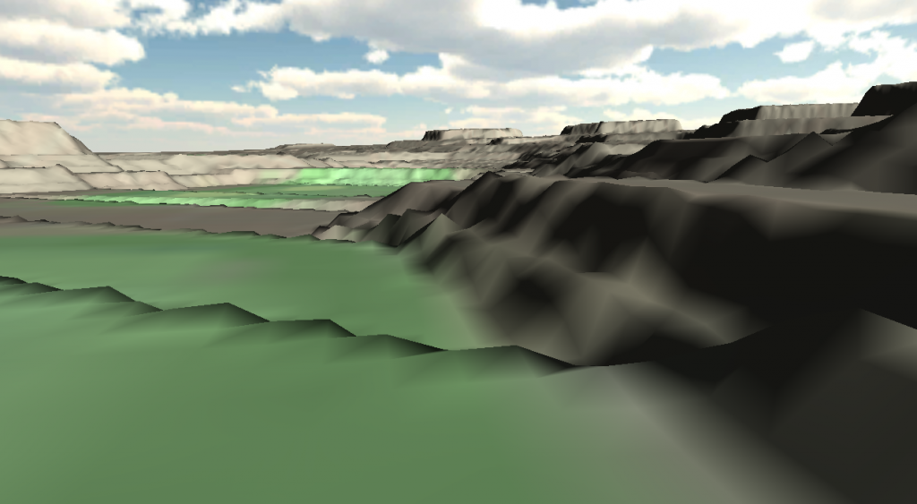
Tried importing a heightmap and I guess the results speak for them selfs...
 Unity_Terrain.jpg 441.71KB
98 downloads
Unity_Terrain.jpg 441.71KB
98 downloads
Mobo: Asus Sabertooth P67 CPU: Intel Core i7-2600K CPU Cooler: Corsair Hydro H60 RAM: Corsair Vengeance DDR 3 1600 MHz 8GB GPU: MSI GeForce 970 GTX Gaming 4G Sound: Creative Soundblaster Extreme Gamer SSD: OCZ Agility 3 64GB HDD: 1x 2TB, 1x 1TB, 1x 320 GB Western Digital PSU: Corsair CX 600W Chassi: Thermaltake Aguila
Advanced Member
Posted 02 June 2013 - 05:18 PM
Advanced Member
Posted 02 June 2013 - 05:52 PM
Photoshop does it, dunno about Gimp though as I've never used it.
For my experiment I used a .tif-file for the overhead, heightmap needs to be .raw though.
Mobo: Asus Sabertooth P67 CPU: Intel Core i7-2600K CPU Cooler: Corsair Hydro H60 RAM: Corsair Vengeance DDR 3 1600 MHz 8GB GPU: MSI GeForce 970 GTX Gaming 4G Sound: Creative Soundblaster Extreme Gamer SSD: OCZ Agility 3 64GB HDD: 1x 2TB, 1x 1TB, 1x 320 GB Western Digital PSU: Corsair CX 600W Chassi: Thermaltake Aguila
Member
Posted 02 June 2013 - 07:32 PM
Tried importing a heightmap and I guess the results speak for them selfs...
ElTee - what was the source of your elevation data for the import? Looks to me like there's no smoothing between discrete elevation heights, it's just interpreting the elevation changes as sharp steps instead...
But I haven't played around with Unity yet, so I can't offer any real help... 
Advanced Member
Posted 02 June 2013 - 08:44 PM
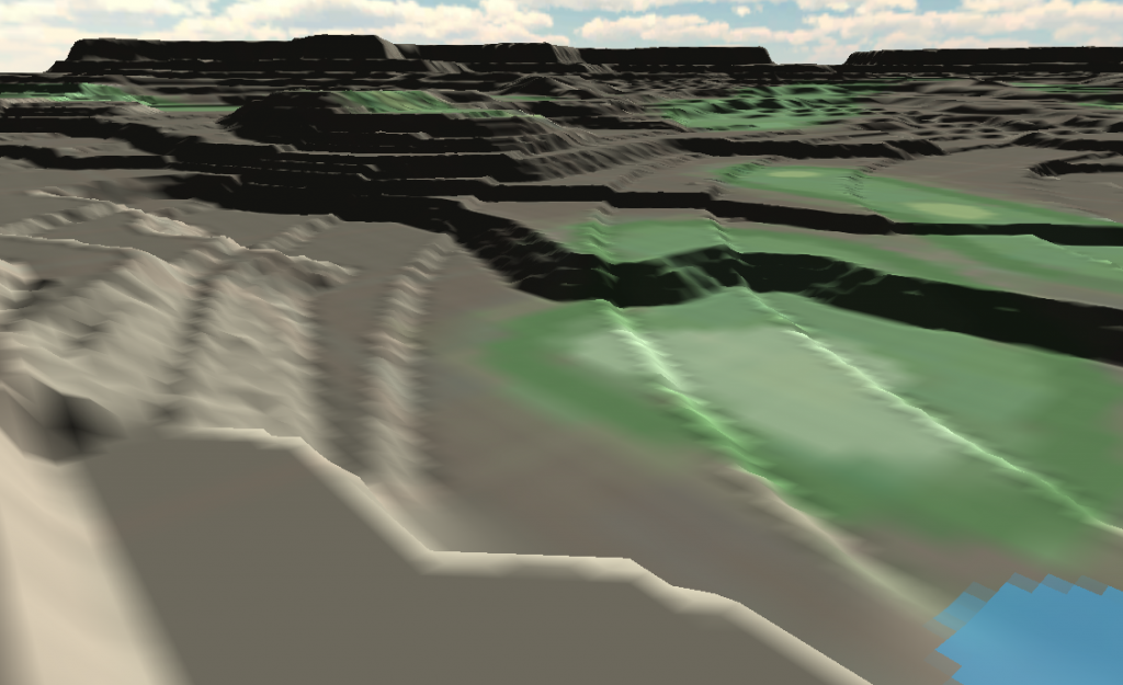
I went to google maps and pulled up a terrain map with 20 meter elevations, used photoshop to draw a line along the elevations and then filled it with colors ranging from 0 to 245, mostly in steps of 20 as that's the elevation change, in greyscale and saved it as a raw file which I then imported into Unity to see what I might be able to do with it. Took quite some time to figure out how the heightmap works in relation to the top view. I was hoping to be able to work with the mesh inside Unity (kinda like with the APCD), but Unity doesn't seem to be the program to use for mesh modification...
As you can see the heightmap is about as good as the end result...
To me it looks like you need to create the mesh for the terrain in a 3D program and then import it into Unity or be patient and wait for PP to roll out Course Forge... 
I am known to be wrong though, and I may very well be so yet again... hehehe
Well, there is a smoothing brush (maximum size of 100, which is tiny on a course 3000 x 3000 m) that you can use to smooth out the terrain, but I'm not sure what I'll wear out first if I try to smooth this terrain out, the desk, the mouse or my arm...
Heightmap.jpg 45.78KB
24 downloads
Mobo: Asus Sabertooth P67 CPU: Intel Core i7-2600K CPU Cooler: Corsair Hydro H60 RAM: Corsair Vengeance DDR 3 1600 MHz 8GB GPU: MSI GeForce 970 GTX Gaming 4G Sound: Creative Soundblaster Extreme Gamer SSD: OCZ Agility 3 64GB HDD: 1x 2TB, 1x 1TB, 1x 320 GB Western Digital PSU: Corsair CX 600W Chassi: Thermaltake Aguila
Administrator
Posted 02 June 2013 - 11:45 PM
This is great news, Andrew. I agree with your comment about the need to crop out just the local course area from the larger grid download. There are still areas available in the NMV where they allow the custom area downloads, but much of it appears to be moving to larger pre-packaged grids. So any tool that helps crop out the desired course area will be a huge advantage. How about orthoimagery from the NMV - are you able to include that in the process so that you end up with aligned image & data?
Advanced Member

Posted 03 June 2013 - 12:14 AM
@Andrew - I'm sure many designers will appreciate the effort you are putting into this, and it will make their real course designs so much easier.
Obscure Person

Posted 03 June 2013 - 07:16 AM
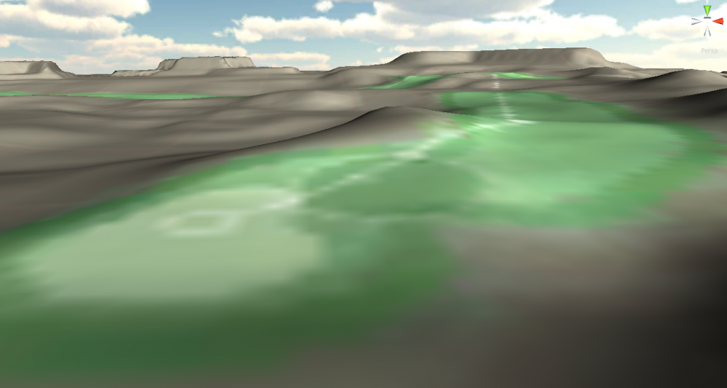
@ At LasseThid: Despair not, this is actually quite good and more useful than you might think. Like you, i tried for quite some time to get nice and smooth heightmaps prepared in photoshop - and failed. Of course, I'm building fantasy courses so that I do not have a reality to deal with. I ended up getting similar results like you, but decided to get them on purpose. And I got this...
It looks horrible, but on the plus side, it gives you a reliable, visual impression of what is up and what is down on your design. It's not finished, by no means, but it's a very useful first draft of your elevations and tells you how the holes will play out individually and in relation to each others.
Once you have this, it's easy to adjust these contours with the Unity Height Brushes and then to even them out with the Smooth Brushes. There's less than five minutes work between the view above and the view below:
Of course, strong smoothing always leads to a shrinking of your land mass. The process reminds me of clay sculpting, where you first cut off large swathes of material and then start working on the medium scale, then on the small one, then on the microscopic one... You just have made the first step, that's all - that's not a failure, it's just a beginning...
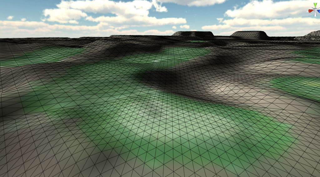
I prepped my first fantasy layout to the point where I need to bring in the CourseForge - of course, if you want to replicate a real terrain, you will need to use real geodata, because I don't think it's possible to construct a heightmap that is accurate enough. If you go for heightmaps, try to work in 16 or 32bit, btw, to increase the resolution.
>>>>>>> Ka-Boom!
• Mulligan Municipal • Willow Heath • Pommeroy • Karen • Five Sisters • Xaxnax Borealis • Aroha • Prison Puttˆ
• The Upchuck • The Shogun • Black Swan (•)
<<<<<
Advanced Member
Posted 03 June 2013 - 04:37 PM
I don't know what's wrong with my heightmap, because the terrain I get is full of spikes, and it got even worse when I changed the resolution to 16 bit. When I tried to smooth the terrain it got flat as a pancake... lol..
Guess I better try to find Bryce or whatever the terrain builders are called nowadays and create a nice plot of land...
Mobo: Asus Sabertooth P67 CPU: Intel Core i7-2600K CPU Cooler: Corsair Hydro H60 RAM: Corsair Vengeance DDR 3 1600 MHz 8GB GPU: MSI GeForce 970 GTX Gaming 4G Sound: Creative Soundblaster Extreme Gamer SSD: OCZ Agility 3 64GB HDD: 1x 2TB, 1x 1TB, 1x 320 GB Western Digital PSU: Corsair CX 600W Chassi: Thermaltake Aguila
Obscure Person
Posted 03 June 2013 - 05:10 PM
When I tried to smooth the terrain it got flat as a pancake... lol..
Correct... if you smooth at full 100% opacity, it will flatten everything. You get more control with smaller brushes and opacities below 20%. You'll get the hang of it - For any heightmap to be of use, it needs to be in one of the following square dimensions, btw: 513x513, 1025x1025, 2049x2049 or 4097x4097 pixels (I use 2049). And the color mode, of course, has to be "grayscale". I'm sure you know all that already and I wouldn't want to imply that you don't. Just in case...
If anybody else has an idea, chime in and help this man, please.
>>>>>>> Ka-Boom!
• Mulligan Municipal • Willow Heath • Pommeroy • Karen • Five Sisters • Xaxnax Borealis • Aroha • Prison Puttˆ
• The Upchuck • The Shogun • Black Swan (•)
<<<<<
Member
Posted 03 June 2013 - 06:34 PM
Looks good, Kablammo! Where are some of the best sites to pull these heightmaps to tinker around with? I'd love to goof around a little.
Advanced Member
Posted 03 June 2013 - 07:27 PM
I can't even get mine to import 


0 members, 0 guests, 0 anonymous users


