Jump to content


Photo

Anyone prepping courses ready to convert in Course Forge?


  • Please log in to reply
49 replies to this topic

#21 LasseThid

LasseThid

    Advanced Member

  • Members
  • PipPipPip
  • 151 posts
  • LocationMölndal, Sweden

Posted 03 June 2013 - 07:42 PM

@ Kablammo: My heightmap (greyscale) was actually only 4096x4096, will try to increase the size to 4097 and see if that makes a difference.

Also I noticed that the brush size and opacity values has a major impact on your results as I tried to "paint" a terrain onto a flat mesh earlier. 

@ Bruce: Send me the file via e-mail or sprend and I'll have a look at it and send it back to you.


Mobo: Asus Sabertooth P67 CPU: Intel Core i7-2600K CPU Cooler: Corsair Hydro H60 RAM: Corsair Vengeance DDR 3 1600 MHz 8GB GPU: MSI GeForce 970 GTX Gaming 4G Sound: Creative Soundblaster Extreme Gamer SSD: OCZ Agility 3 64GB HDD: 1x 2TB, 1x 1TB, 1x 320 GB Western Digital PSU: Corsair CX 600W Chassi: Thermaltake Aguila


#22 rwmorey

rwmorey

    Advanced Member

  • Members
  • PipPipPip
  • 37 posts

Posted 03 June 2013 - 07:49 PM

I too am interested in pulling height maps. I did some experimentation with one of the tutorials I found online but didn't end up with anything that looked other than flat ground in Unity. Of course, I may have messed up a step (or three).


#23 LasseThid

LasseThid

    Advanced Member

  • Members
  • PipPipPip
  • 151 posts
  • LocationMölndal, Sweden

Posted 04 June 2013 - 04:42 AM

Basically importing a heightmap is really simple, it's the rest that's the problem.  :D

Open a new scene. Go to Terrain > Create Terrain, then Terrrain > Set Resolution, enter values for width, height, length and so on and then Terrain > Import heightmap... Raw

Use the same values for width, height and length as when you set the resolution and you're done.


Also with regards to heightmaps it seems that 8-bit greyscale is easier on your system than a 16-bit greyscale. For instance I have no problem working with an 8-bit file 4096x4096, but my system chokes on a 16-bit 2048x2048 even with 8 Gb RAM... :( 


Mobo: Asus Sabertooth P67 CPU: Intel Core i7-2600K CPU Cooler: Corsair Hydro H60 RAM: Corsair Vengeance DDR 3 1600 MHz 8GB GPU: MSI GeForce 970 GTX Gaming 4G Sound: Creative Soundblaster Extreme Gamer SSD: OCZ Agility 3 64GB HDD: 1x 2TB, 1x 1TB, 1x 320 GB Western Digital PSU: Corsair CX 600W Chassi: Thermaltake Aguila


#24 Kablammo11

Kablammo11

    Obscure Person

  • Members
  • PipPipPip
  • 3,953 posts

Posted 04 June 2013 - 06:55 AM

@HalkeFralg (Looks good, Kablammo! Where are some of the best sites to pull these heightmaps to tinker around with? I'd love to goof around a little.)


Mine are self made. I basically first draw the layout of the courses in Photoshop. You need to mind the distances: This plot of land is 1600 by 1600 meters, for instance. I added distance lines to measure the length of every hole (100 yds = 90meters) and even landing areas for the drives. Deatils like bunkers and exact contours will be added later (when that %**! CourseForge is finally released.. :huh: ).

So, This file I added as a terrain texture on a flat piece of Unity terrain.


RampRv2-Layout2copy_zps823d7350.jpg


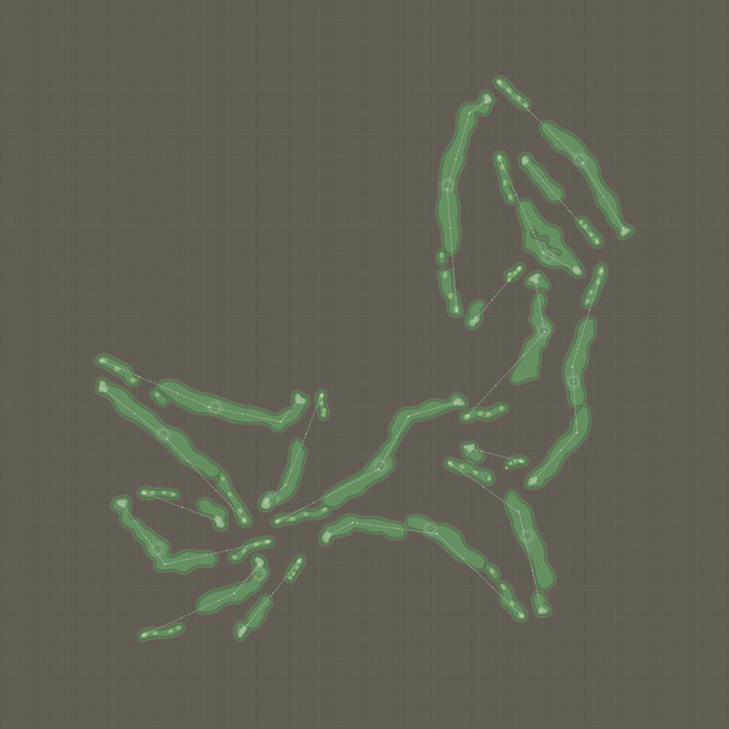
Next, still in Photoshop, on a layer below, I drew my heightmap. Black is low, white is high. I did not go for smoothness, I just built steps in the terrain telling Unity what was up and what was down. I like playing god with the world, so issuing decrees to an image on what is hill and what is vale is something I find deeply satisfying. Why use a real terrain when you, for once, can create one yourself? I also heightened the eastern half of the course, making it slope up from bottom left to top right, elevating the ridge in the middle... You may note that this heightmap is flipped vertically. Unity reads it that way...


RampRv2-HMcopy_zps65ca5857.jpg


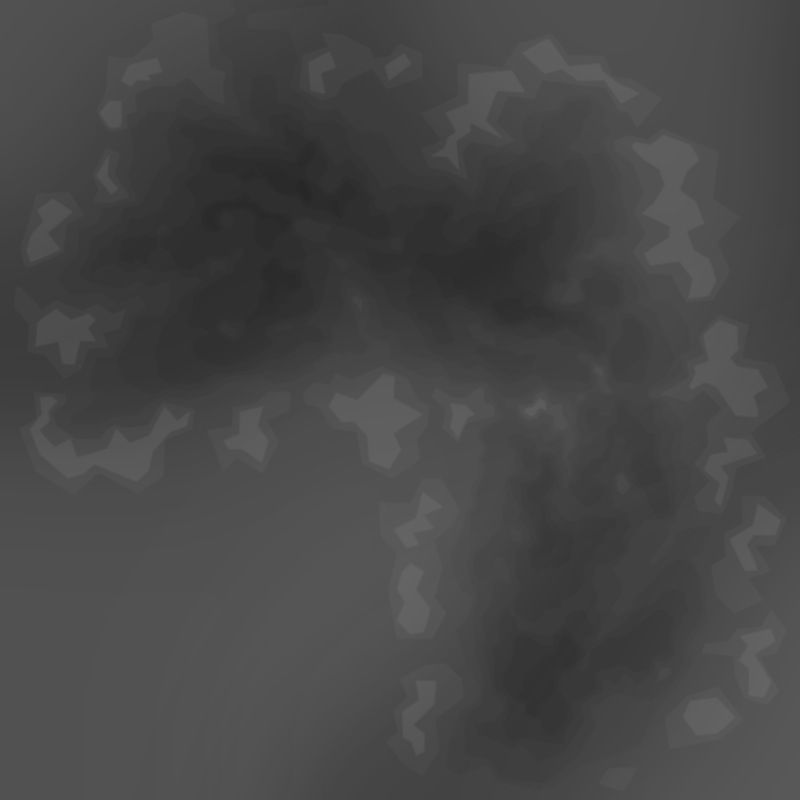
I saved the Photoshop image with this heightmap in grayscale mode, 16bit, 2049x2049 pixels, in the format "Photoshop Raw", then imported it into Unity the way Lasse described above. That resulted into the 1st two images of my previous post, those spiky, steppy monstrosities that just needed a bit of smooth to form into a golfable terrain... 


I'm sure there must be already finished heightmaps on the web, though. Try Google images...


ADDENDUM:

I think it has become clear to me that both GPS data or heightmaps are really a very basic first step. Do not import a heightmap or a 3D mesh from reality and think to yourself that that is it and your terrain is okay. It's not. There's a lot of work yet to be done, you will need to go over every detail of your course several times, nip and tuck, refine, etc... Which, to me, actually is fun to do. Heightmaps are just a very useful help to determine the lay of the land. 95% (or more) of your work is still ahead of you.


>>>>>>> Ka-Boom!


• Mulligan Municipal • Willow Heath • Pommeroy • Karen • Five Sisters • Xaxnax Borealis • Aroha • Prison Puttˆ

• The Upchuck   The Shogun  • Black Swan (•)


<<<<<


#25 Andrew

Andrew

    Administrator

  • Administrators
  • 2,524 posts
  • LocationUSA

Posted 04 June 2013 - 12:48 PM

I can't even get mine to import  :(

Yeah, first time I played around with Unity I suffered from this too.  IT is remarkably sensitive to data in the correct format.  This was why I started work on the Terrain Importer.  


#26 Andrew

Andrew

    Administrator

  • Administrators
  • 2,524 posts
  • LocationUSA

Posted 04 June 2013 - 02:50 PM

New Video is out...


  • garynorman likes this

#27 LasseThid

LasseThid

    Advanced Member

  • Members
  • PipPipPip
  • 151 posts
  • LocationMölndal, Sweden

Posted 04 June 2013 - 03:16 PM

New Video is out...

Really nice way of importing terrain into Unity. It's a shame it's only working for a small part of the world though... :P


Mobo: Asus Sabertooth P67 CPU: Intel Core i7-2600K CPU Cooler: Corsair Hydro H60 RAM: Corsair Vengeance DDR 3 1600 MHz 8GB GPU: MSI GeForce 970 GTX Gaming 4G Sound: Creative Soundblaster Extreme Gamer SSD: OCZ Agility 3 64GB HDD: 1x 2TB, 1x 1TB, 1x 320 GB Western Digital PSU: Corsair CX 600W Chassi: Thermaltake Aguila


#28 Andrew

Andrew

    Administrator

  • Administrators
  • 2,524 posts
  • LocationUSA

Posted 04 June 2013 - 04:53 PM

Really nice way of importing terrain into Unity. It's a shame it's only working for a small part of the world though... :P

If people point me in the direction of free elevation data in their countries I am happy to try and add the data formats into the Terrain Importer... Of course if your country does not provide hi resolution elevation data for free I cannot help much... Perhaps if they raised taxes?:)


#29 Brucey Mc

Brucey Mc

    Advanced Member

  • Members
  • PipPipPip
  • 438 posts
  • LocationTeesside, UK #UTB

Posted 04 June 2013 - 04:57 PM

We seem to be having our annual two days of sun in the UK at the moment so haven't spent much time on the computer messing about with height maps  :D


#30 LasseThid

LasseThid

    Advanced Member

  • Members
  • PipPipPip
  • 151 posts
  • LocationMölndal, Sweden

Posted 04 June 2013 - 05:37 PM

If people point me in the direction of free elevation data in their countries I am happy to try and add the data formats into the Terrain Importer... Of course if your country does not provide hi resolution elevation data for free I cannot help much... Perhaps if they raised taxes? :)

I'm just joking Andrew. You guys are doing an amazing job with PG, CF and the terrain importer. 

Even with our high taxes the government doesn't bother to provide free evelation data, besides that the courses I'd like to do aren't even in my home country..  :D

Can't wait to try to do something constructive with CF.


Mobo: Asus Sabertooth P67 CPU: Intel Core i7-2600K CPU Cooler: Corsair Hydro H60 RAM: Corsair Vengeance DDR 3 1600 MHz 8GB GPU: MSI GeForce 970 GTX Gaming 4G Sound: Creative Soundblaster Extreme Gamer SSD: OCZ Agility 3 64GB HDD: 1x 2TB, 1x 1TB, 1x 320 GB Western Digital PSU: Corsair CX 600W Chassi: Thermaltake Aguila


#31 Brucey Mc

Brucey Mc

    Advanced Member

  • Members
  • PipPipPip
  • 438 posts
  • LocationTeesside, UK #UTB

Posted 04 June 2013 - 07:04 PM

Yeah, first time I played around with Unity I suffered from this too.  IT is remarkably sensitive to data in the correct format.  This was why I started work on the Terrain Importer.  

And there are an awful lot of us that are glad that you did Andrew!


#32 Brucey Mc

Brucey Mc

    Advanced Member

  • Members
  • PipPipPip
  • 438 posts
  • LocationTeesside, UK #UTB

Posted 04 June 2013 - 08:36 PM

Andrew, will there be a video for people wanting to create a terrain from an ascii source?


#33 Davefevs

Davefevs

    Advanced Member

  • Members
  • PipPipPip
  • 454 posts
  • LocationBristol

Posted 04 June 2013 - 09:39 PM

Andrew, will there be a video for people wanting to create a terrain from an ascii source?


Bruce - have you had a look at the OS Terrain 50 on the Ordnance Survey website, here's the spec:

Technical details

Format: Grid points for DTM and vector point and line for contours

Data structure: GML 3.2 and ASCII grid for DTM, GML 3.2 and Esri® shapefile for contours

Resolution: DTM: grid points have a post spacing of 50m. Contours: vertical interval of 10m.

Tile size: 10km x 10km

Scale: 1:50 000

Supply: Download (annual contract)

Update Frequency: annually

Coverage: Great Britain

#34 Brucey Mc

Brucey Mc

    Advanced Member

  • Members
  • PipPipPip
  • 438 posts
  • LocationTeesside, UK #UTB

Posted 04 June 2013 - 10:38 PM

Dave

I haven't yet. I have some decent terrain data in acii for a couple of courses in the uk I would like to do and I might consider looking at terrain for my local course further down the line but I would need a source for that. Decent data in the uk ain't cheap from what I remember from my apcd dabbling days!

#35 Davefevs

Davefevs

    Advanced Member

  • Members
  • PipPipPip
  • 454 posts
  • LocationBristol

Posted 04 June 2013 - 10:45 PM

I downloaded my local 'grid', but have yet to open it up yet. I'm a real novice and hoping to get started using Bing maps import. May find that it isn't anywhere detailed enough. Then again I don't expect to be creating masterpieces!

It is interesting reading all the terrain data stuff on the Internet though!

#36 TimBoch

TimBoch

    Advanced Member

  • Members
  • PipPipPip
  • 359 posts
  • LocationFarmington, MN

Posted 04 June 2013 - 11:10 PM

First try at importing a custom texture.


Course Forge Courses in various stages of design: Dwan Golf Club, Hyland Greens, Faribault CC, Desert Valley CC/ Woodland Trail(fictional), Infamous Golf Course (fantasy)
Links 2003 Designs: Dwan Golf Club, Infamous Golf Course, Hazeltine National Golf Club (assistant designer), Woodland Trail/Desert Valley CC , Faribault CC (beta), Hyland Greens (beta), Double Eagle (beta), King's Walk (beta), Interlachen CC (still in planning)
Intel Core i7-4710HQ 2.5GHz
  • Microsoft Windows 8.1 64-bit
  • 16GB DDR3L RAM
  • 750GB 7,200RPM Hard Drive
  • NVIDIA GeForce GTX 850M

#37 Dazmaniac

Dazmaniac

    Rock. Loud and Heavy

  • Members
  • PipPipPip
  • 6,941 posts
  • LocationEngland, UK

Posted 04 June 2013 - 11:19 PM

A Hazeltine GC custom texture too, lol.


Good stuff Tim.


;)


#38 HalkeFralg

HalkeFralg

    Member

  • Members
  • PipPip
  • 23 posts

Posted 05 June 2013 - 12:16 AM

Very Nice, Tim. Where did you get the data from?


#39 TimBoch

TimBoch

    Advanced Member

  • Members
  • PipPipPip
  • 359 posts
  • LocationFarmington, MN

Posted 05 June 2013 - 02:51 AM

Very Nice, Tim. Where did you get the data from?

It is just a texture tif I made from piecing together an overhead off of Bing maps.  Thought of doing some basic elevating and planting just to get better acquainted with Unity.  I am hoping when the importer comes out, that I can put to use the elevation data Joe gave me last fall and make a much better version of Hazeltine than I made in APCD.


Course Forge Courses in various stages of design: Dwan Golf Club, Hyland Greens, Faribault CC, Desert Valley CC/ Woodland Trail(fictional), Infamous Golf Course (fantasy)
Links 2003 Designs: Dwan Golf Club, Infamous Golf Course, Hazeltine National Golf Club (assistant designer), Woodland Trail/Desert Valley CC , Faribault CC (beta), Hyland Greens (beta), Double Eagle (beta), King's Walk (beta), Interlachen CC (still in planning)
Intel Core i7-4710HQ 2.5GHz
  • Microsoft Windows 8.1 64-bit
  • 16GB DDR3L RAM
  • 750GB 7,200RPM Hard Drive
  • NVIDIA GeForce GTX 850M

#40 SouthStPaul

SouthStPaul

    Advanced Member

  • Members
  • PipPipPip
  • 44 posts
  • LocationSouth Saint Paul, MN USA

Posted 05 June 2013 - 03:22 AM

It is just a texture tif I made from piecing together an overhead off of Bing maps.  Thought of doing some basic elevating and planting just to get better acquainted with Unity.  I am hoping when the importer comes out, that I can put to use the elevation data Joe gave me last fall and make a much better version of Hazeltine than I made in APCD.

Do you have good picks of the new clubhouse?


I think the snow is starting to let up! :lol:


0 user(s) are reading this topic

0 members, 0 guests, 0 anonymous users