

4096 made it better thanks. Truecolour/compressed I didn't see a difference but I'll keep it in mind.

Course height maps
Started by
jt83
, Aug 09 2018 09:34 AM
158 replies to this topic
#41

clubcaptain
-

- Members
-

- 1,310 posts
Advanced Member
Posted 10 February 2019 - 08:13 PM
PC specs...
Intel core I7 9700k 3.6 GHZ-Turbo 4.9 GHZ
64 GB Corsair vengeance LPX DDR4 2400 MHZ
Asus PRIME Z390-P
Nvidea GeForce RTX 2060 6GB
X box 360 wired controller
Windows 10 PRO NA 64 bit
#42
Justin9926
-

- Members
-
- 760 posts
Advanced Member
Posted 10 February 2019 - 08:59 PM
Yes, I don't see a difference between being compressed or true color. But you'll see the difference when it comes time to build the course. Your course file will be 40 or 50 MB larger if you have it set to True color. For example if you have your Overhead image sent to 4096 compressed its 10 MB. But if you have it set for 4096 true color it 64 MB. If you're not using the overhead technique where you're going back and forth with Photoshop I would leave it set at compressed.
Are you building the course just normal? Or are you trying to build it with the course overlay technique?
Asus ROG G751JT-CH71 Gaming Laptop
2.5 GHz Intel Core i7– 4710HQ
Nvidia GTX 970M 3GB GDDR5
16 GB DDR3
Windows 10 64-bit
#43
clubcaptain
-
- Members
-
- 1,310 posts
Advanced Member
Posted 11 February 2019 - 01:03 AM
Normal at present just getting the feel of things.
PC specs...
Intel core I7 9700k 3.6 GHZ-Turbo 4.9 GHZ
64 GB Corsair vengeance LPX DDR4 2400 MHZ
Asus PRIME Z390-P
Nvidea GeForce RTX 2060 6GB
X box 360 wired controller
Windows 10 PRO NA 64 bit
#44
clubcaptain
-
- Members
-
- 1,310 posts
Advanced Member
Posted 11 February 2019 - 03:31 PM
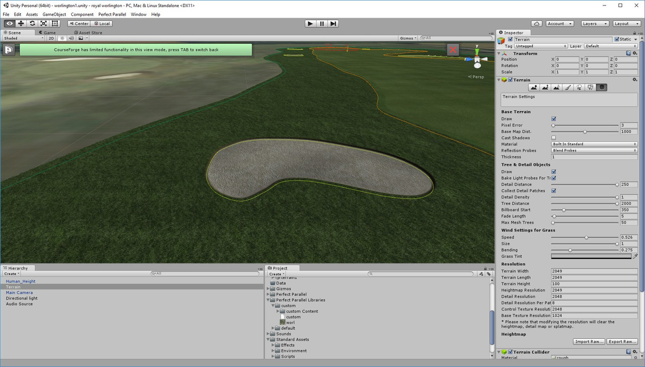
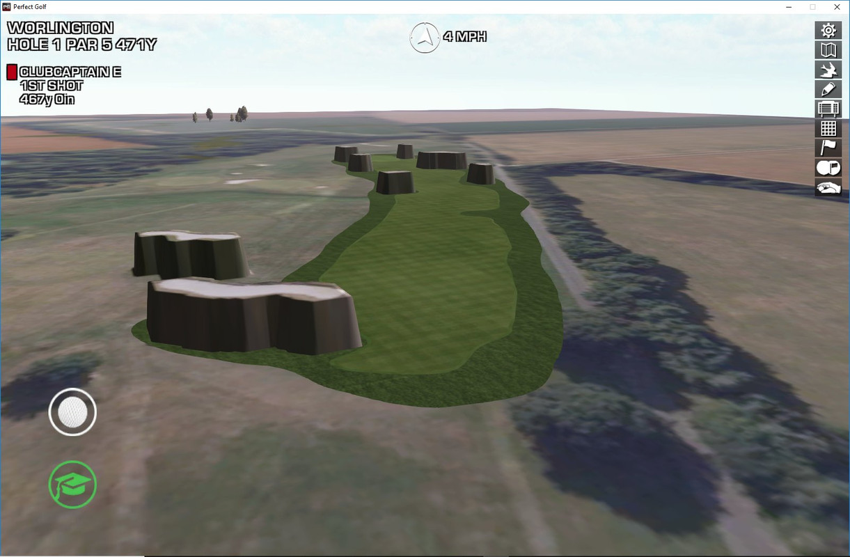
Trying to create Royal Worlington using the heightmap and overhead image from here :-
http://www.perfectpa...se-height-maps/
This image shows the bunkers sitting down in CF.
https://i.postimg.cc...nkers-in-CF.jpg
but in game they are all raised up.
No doubt someone can help.
PC specs...
Intel core I7 9700k 3.6 GHZ-Turbo 4.9 GHZ
64 GB Corsair vengeance LPX DDR4 2400 MHZ
Asus PRIME Z390-P
Nvidea GeForce RTX 2060 6GB
X box 360 wired controller
Windows 10 PRO NA 64 bit
#45
jt83
-
- Members
-
- 1,039 posts
Advanced Member
Posted 12 February 2019 - 05:53 AM
Terrain height should be 23.8, detail res should be 1028. Not sure if that's the problem but it's a start.
#46
Justin9926
-
- Members
-
- 760 posts
Advanced Member
Posted 12 February 2019 - 01:25 PM
I have my detail resolution set to 2048. That's also what Mike has the CF tutorial set for. But I don't think that's his problem anyhow. I sent you a PM.
Asus ROG G751JT-CH71 Gaming Laptop
2.5 GHz Intel Core i7– 4710HQ
Nvidia GTX 970M 3GB GDDR5
16 GB DDR3
Windows 10 64-bit
#47
jt83
-
- Members
-
- 1,039 posts
Advanced Member
Posted 20 February 2019 - 06:43 AM
Tidied up and updated.
Some notes -
Some courses might be on someone's to do list on OGT.
If the terrain dimensions are 2049x2049, assume the height map resolution is also 2049.
For anyone just starting out, please go through the tutorials (official and community) and consider the look you want. A lot can be accomplished with some basic adjusting in the layers library.
United Kingdom -
Prestwick (Scotland, 2049x2049, height 18.4) - https://mega.nz/#F!S...dsW_YNZs2fU-U_g
Royal Lytham (England, 2049x2049, height 12.4) - https://www.dropbox....qAQ8t0F98a?dl=0
Royal St Davids (Wales, 2049x2049, height 154) - https://www.dropbox...._4iDmzfrYa?dl=0
Royal Worlington (9 holes, England, 2049x2049, height 23.8, clubcaptain in progress?) - https://www.dropbox....bxEBz6GD9a?dl=0
Walton Heath (England, 2049x2049, height 52) - https://www.dropbox....YRnRanHvYa?dl=0
Cruden Bay (Scotland, 2400x2400, 65.9, resolution 2049) - https://mega.nz/#F!m...ag36tnL4q7kejbg
Hoylake (England, 2049x2049, 32.2) - https://www.dropbox....m-PLnT4cBa?dl=0
Kingsbarns (Scotland, 2049x2049, 47, Cintigolfer in progress?) - https://mega.nz/#F!W...vvwOrgCJAqak_XQ
North Berwick (Scotland, 3000x3000, 63.3, resolution 4097) - https://mega.nz/#F!e...4fxdRhtALAPYuQQ
Pennard (Wales, 2049x2049, 78.9, DPRoberts in progress?) - https://www.dropbox....dtzE2hmEa?dl=0
Stoke Park (England, 2049x2049, 24.2) - https://mega.nz/#F!2...q-l9FGIo86Xapww
Westward Ho! (England, 2049x2049, 49.1) - https://mega.nz/#F!r...TOxEw1s11iXEs6A
West Sussex (England, 2049x2049, 36) - https://mega.nz/#F!v...zEhlgfR3mrBPwhg
Europe -
Linna (Finland, 2049x2049, 68.3) - https://mega.nz/#F!a...-LE-mRY0qza2a4g
Hubbelrath and Koln (Germany, both 2049x2049, 85.2, 39.9) - https://www.dropbox....WmYn83OyZa?dl=0
Sotogrande (Spain, 2049x2049, 68) - https://www.dropbox....11xzU7_pGa?dl=0
Valderrama (Spain, 2049x2049, 119.2) - https://mega.nz/#F!S...Wo2rmQ1ix4R58wg
Kennemer (Netherlands, 2049x2049, 34.9) - https://mega.nz/#F!L...woi5htNzT-0l_zw
Lofoten (Norway, 1200x1200, 70.6, resolution 1025, needs a Northern lights skybox!) - https://mega.nz/#F!e...pRBF-PoQDzxp_ZQ
Scandinavian Golf Club (Denmark, 2049x2049, 26.3) - https://mega.nz/#F!O...6g6StK79w-43CEg
USA/Canada -
Baltimore Five Farms (USA, 2049x2049, 80.7) - https://mega.nz/#F!G...NcCeKVI4WFYlxlQ
Kapalua Bay (USA, 2300x2300, 102.5, resolution 2049) - https://mega.nz/#F!v...3z16FgvSE7kUIzg
Maidstone (USA, 2049x2049, 16.8) - https://mega.nz/#F!q...IRh3rjEQ3XbBO4Q
The Golf Club (USA, 2049x2049, 25.3) - https://mega.nz/#F!z...rpRjp8_pw81k1oA
Fox Chapel (USA, 2049x2049, 111.7, jmd1235 in progress) - https://mega.nz/#F!v...7jYIuRZp4VDFYAA
Hunter Station (USA, 2049x2049, 183.2) - https://mega.nz/#F!f...3fU1PXXsyBIK-WA
Lehigh (USA, 2049x2049, 53.6) - https://mega.nz/#F!q...wBCelPSAqBal7Pg
San Francisco (USA, 1500x1500, 95.6, resolution 1025) - https://mega.nz/#F!z...q7zP_Jo2G2aolRg
Meadow Golf Club (USA, 2049x2049, 328.5) - https://mega.nz/#F!H...IfYBq4FeT84ugVw
Northwood (9 holes, USA, 1000x1000, 132.5, resolution 1025) - https://mega.nz/#F!3...NWAZg7KOP6AjIVA
Garden City (USA, 1450x1450, 16.5, resolution 1025) - https://mega.nz/#F!e...aFL15cfbPNZHaBw
Honors Course (USA, 1500x1500, 139.7, resolution 1025) - https://mega.nz/#F!i...rW6D7IFHNZNCrMQ
Pumpkin Ridge (USA, 2049x2049, height 97, Dace doing Witch Hollow half?) - https://www.dropbox....a_K3rcawa?dl=0
Fairmont Algonquin (Canada, 2049x2049, 58.8) - https://www.dropbox....UC2LIRGnNa?dl=0
The rest -
Hirono (Japan, 2049x2049, 137.7) - https://mega.nz/#F!a...YFuxuNa-1e9ENfw
Dorado Beach East (Puerto Rico, 2049x2049, 23.9) - https://mega.nz/#F!P...OzODzNUSFf2V2Gg
Manila Southwoods (Philippines, 2049x2049, 59.7, Birdie in progress) - https://mega.nz/#F!u...jBODj_tD7mHhX4g
- IanK likes this
#48
shimonko
-

- Members
-
- 1,718 posts
Advanced Member
Posted 20 February 2019 - 07:55 AM
Nice job. I know you said the dimensions may refer to overhead or terrain, but the 1025's and 2049's are looking like heightmap resolutions - it would be a bit strange to have those as overhead or terrain dimensions (1024 or 2048 is more likely, or 1500, 2300,... like you have for some).
Unlike heightmap and overhead sizes, terrain dimensions can't be deduced from the files - do you assume a standard 2000 x 2000m terrain or something for those?
#49
jt83
-
- Members
-
- 1,039 posts
Advanced Member
Posted 20 February 2019 - 08:38 AM
This is something I have to fix, there are courses like San Fran where the 1500 figure is the terrain dimension, but I haven't noted the height map resolution. In cases like that I'm pretty sure I always opted for a resolution as close as possible to the terrain, so in San Fran's case it would be 1025 (closer than 2049). In the majority of maps 2049 refers to the terrain dimensions and the height map resolution, but I'll fix it so that there's no confusion.
- shimonko likes this
#50
jt83
-
- Members
-
- 1,039 posts
Advanced Member
Posted 21 February 2019 - 11:32 AM
Should be easier to comprehend now. Golden Horseshoe's map has been fixed and Sotogrande's overhead now matches when the lidar was done. Valderrama's overhead wasn't replaced, the changes done there were minimal.
#51
amc
-

- Members
-
- 10 posts
Member
Posted 26 February 2019 - 03:24 AM
Nice work, JT! These are great. Thanks for putting these up.
How do you make these? I've been trying to get the Lidar for Barnbougle Dunes, and while I managed to get some GeoTiffs from 'Elvis' (http://elevation.fsdf.org.au/), it occurred to me that I didn't have the overhead and didn't really have any good idea as to how to go about it.
And how do you deduce the heightmap value from the raw file?
Thanks!
#52
Larrykuh
-

- Members
-
- 244 posts
Advanced Member
Posted 26 February 2019 - 03:35 AM
Golden Horeshoe - Gold course is close to a beta release by HammondGolf.
#53
jt83
-
- Members
-
- 1,039 posts
Advanced Member
Posted 26 February 2019 - 03:57 AM
Nice work, JT! These are great. Thanks for putting these up.
How do you make these? I've been trying to get the Lidar for Barnbougle Dunes, and while I managed to get some GeoTiffs from 'Elvis' (http://elevation.fsdf.org.au/), it occurred to me that I didn't have the overhead and didn't really have any good idea as to how to go about it.
And how do you deduce the heightmap value from the raw file?
Thanks!
If you're interested in the workflow check out Joe H's tutorials. Basically you start with data (GeoTiff, point cloud etc), match up the overhead imagery, and take the generated terrain file through a couple of programs (the height is found out along the way) to end up with a raw file. There's other little things I've had to learn along the way but his tutes are a great starting point. ELVIS has point cloud data which is the best way to start. Barnbougle sadly only has about 9 holes covered so I didn't bother going through the process.
Golden Horeshoe - Gold course is close to a beta release by HammondGolf.
Hopefully not based on my first map 
#54
amc
-
- Members
-
- 10 posts
Member
Posted 26 February 2019 - 05:53 AM
If you're interested in the workflow check out Joe H's tutorials. Basically you start with data (GeoTiff, point cloud etc), match up the overhead imagery, and take the generated terrain file through a couple of programs (the height is found out along the way) to end up with a raw file. There's other little things I've had to learn along the way but his tutes are a great starting point. ELVIS has point cloud data which is the best way to start. Barnbougle sadly only has about 9 holes covered so I didn't bother going through the process.
Ah, I see them. Thank you. I'll check those out.
Shame about Barnbougle. Obviously just a bit too close to the middle of nowhere
#55
Larrykuh
-
- Members
-
- 244 posts
Advanced Member
Posted 26 February 2019 - 02:58 PM
Hopefully not based on my first map
No, I created a heightmap for him.
#56
Jugador
-

- Members
-
- 619 posts
Advanced Member
- LocationDallas, TX
Posted 18 April 2019 - 09:31 PM
Hi fellows...newb to CF and would like to learn doing my home course. If one of you gentleman could put a lidar/image package together for me,(if it's available) would be eternally grateful!  The name of the course is Pecan Valley. Roughly 32-39-30 N___97-27-6 W. There's 3 courses in the vicinity, and I would like the one in the middle. I've attached a pic to make it easier for you to spot. Thanks!
AMD RYZEN 7800 X3D
RTX 4070 ti
32 gb DDR 5
360mm AIO
#57
Joe Habiger
-

- Members
-
- 1,037 posts
Advanced Member
- LocationCoon Rapids, MN
Posted 18 April 2019 - 10:37 PM
I've got it, i'll send a link in a bit. Would have been nice to tell us what town it was in though as it would have been easier to find..lol
EDIT - Uploading now in .zip format, just unzip it to my documents folder and when you open unity click on OPEN upper right and point to the pecan_valley folder. Now just click on your assets tab and double click your pecan_valley.unity file so it will load up for you. Everything is already set so all you should have to do is turn on course forge and go. I'll post link when it's uploaded fully. It's an 881 meg zip file but this should include everything you need for now anyways.
DOUBLE EDIT - https://mega.nz/#!Lp...mBu-zQJGZJLRkeo
Have fun!!
- AMD Ryzen 7 5800X
- Asus ROG Strix B550-F Gaming
- Sapphire Nitro+ SE AMD Radeon 6800XT
- G.Skill Trident Z Royal RGB 16GB DDR4-3600
- Sabrent 2TB Rocket NVMe 4.0 Gen 4 PCIe M.2
- Samsung 970 EVO Plus 1TB SSD M.2 NVMe
- Samsung 850 EVO 512GB SSD
- Sound Blaster ZX Soundcard
- EVGA 750 Gold Power Supply
- Fractal Design Meshify S2 Case
- Cooler Master MasterLiquid ML360R
- "43 inch Vizio 4k Monitor
#58
Jugador
-
- Members
-
- 619 posts
Advanced Member
- LocationDallas, TX
Posted 19 April 2019 - 12:46 AM
I've got it, i'll send a link in a bit. Would have been nice to tell us what town it was in though as it would have been easier to find..lol
Have fun!!
You mean you have never heard of the world famous Pecan Valley golf course ? lol
BTW...really enjoy your tutorial videos!
I'm anxious to get started, now. It does sound like it will be fun.
Thank you very much, Sir.
Dan
AMD RYZEN 7800 X3D
RTX 4070 ti
32 gb DDR 5
360mm AIO
#59
Jugador
-
- Members
-
- 619 posts
Advanced Member
- LocationDallas, TX
Posted 20 April 2019 - 04:11 AM
Tidied up and updated.
Some notes -
Some courses might be on someone's to do list on OGT.
If the terrain dimensions are 2049x2049, assume the height map resolution is also 2049.
For anyone just starting out, please go through the tutorials (official and community) and consider the look you want. A lot can be accomplished with some basic adjusting in the layers library.
Thank you, sir...very nice of you to post these. I took a couple at random from each country. This should keep me
entertained for awhile!
AMD RYZEN 7800 X3D
RTX 4070 ti
32 gb DDR 5
360mm AIO
#60
brokenclub
-

- Members
-
- 121 posts
Advanced Member
Posted 29 April 2019 - 01:33 PM
Hello Gentlemen, A few years ago I had a height map for a local course here in Puerto Rico. I had some holes competed, but then had a crash. The height map i had was lost with everything. An Gentlemen from OGT had originally got the height map for me . it was crude, but it was something to go with. I not a member of OGT any longer, so dont know how to contact him.
Then I saw this tread and thought I'd ask. The Course is the Borinquen Golf Club located on the Northwest Coast Of Puerto Rico, next to the Aquadilla Airport.
I have download lots of stuuff, If I get a new heightmap I'll be set to try again.
Thanks For Reading
Tim


1 user(s) are reading this topic
0 members, 1 guests, 0 anonymous users


