

Here is the heightmap for Borinquen Golf Club. This one should be much better than your original as it is based on hi-res lidar.
https://www.dropbox....itypackage?dl=0

Course height maps
Started by
jt83
, Aug 09 2018 09:34 AM
158 replies to this topic
#61

Larrykuh
-

- Members
-

- 244 posts
Advanced Member
Posted 29 April 2019 - 02:35 PM
#62
brokenclub
-

- Members
-
- 121 posts
Advanced Member
Posted 29 April 2019 - 03:32 PM
Larrykuh.. Wow What a better overlay and height map, then the one I had. I'm now inspired to start and finish this course. Thanks alot for taking the time to create a unity package, speeded things up for sure.
Now to look at Mike's video's to re-learn some things.
Thanks again
Tim
#63
Jugador
-

- Members
-
- 619 posts
Advanced Member
- LocationDallas, TX
Posted 01 May 2019 - 02:56 AM
I've got it, i'll send a link in a bit. Would have been nice to tell us what town it was in though as it would have been easier to find..lol
EDIT - Uploading now in .zip format, just unzip it to my documents folder and when you open unity click on OPEN upper right and point to the pecan_valley folder. Now just click on your assets tab and double click your pecan_valley.unity file so it will load up for you. Everything is already set so all you should have to do is turn on course forge and go. I'll post link when it's uploaded fully. It's an 881 meg zip file but this should include everything you need for now anyways.
DOUBLE EDIT - https://mega.nz/#!Lp...mBu-zQJGZJLRkeo
Have fun!!
Hi Mr. Habiger...just realized you went waaaaay beyond the call of duty. Just another BIG thanks for including a bunch of "extras" in my package. I owe you one!

- Joe Habiger likes this
AMD RYZEN 7800 X3D
RTX 4070 ti
32 gb DDR 5
360mm AIO
#64
jt83
-
- Members
-
- 1,039 posts
Advanced Member
Posted 19 May 2019 - 09:50 AM
Highlands Links (Canada, 3400x3400, resolution 4097, height 299.2) - https://mega.nz/#F!u...kDwCapEPVmHjzkg
#65
jt83
-
- Members
-
- 1,039 posts
Advanced Member
Posted 26 May 2019 - 02:34 AM
Ballybunion (Ireland, 1800x1800, resolution 1025, height 31.8) - https://mega.nz/#F!D...5D1Ws-oSkafuxZQ
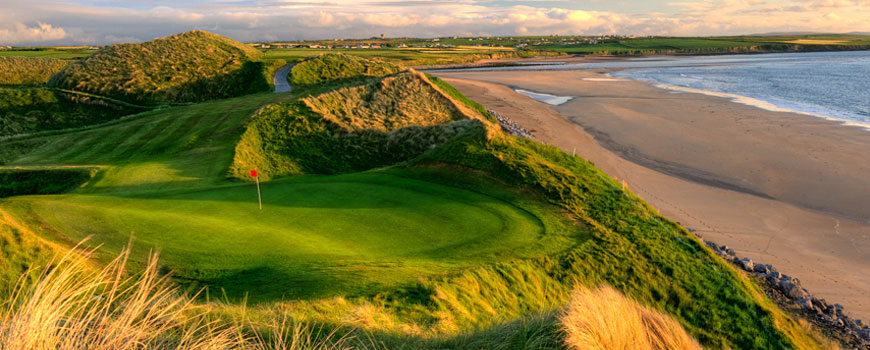
Thanks goes to Bluesky (https://www.bluesky-world.ie) for providing the sample. IMO one of the last top 10ish courses the game would love (not sure what's happening with Oakmont.)
#66
brokenclub
-
- Members
-
- 121 posts
Advanced Member
Posted 13 June 2019 - 01:29 PM
Hello, have been working on my Punta Borinquen course, which larrykuh provided excellant lidar data. watching tons of videos and slowly proceeding. I'd also like to do a course next Bergen Point GC on the south shore of long island in west babylon (11704) . I play borinquen in winter and bergen in summers. would love to get a lidar for bergen point. played both for years.
#67
Larrykuh
-
- Members
-
- 244 posts
Advanced Member
Posted 13 June 2019 - 03:18 PM
I have the lidar downloaded and will have the heightmap for you later today.
#68
brokenclub
-
- Members
-
- 121 posts
Advanced Member
Posted 13 June 2019 - 04:40 PM
thank you ,.. the lidar i have for borinquen is so good i'm almost afraid to touch it
#69
Larrykuh
-
- Members
-
- 244 posts
Advanced Member
Posted 14 June 2019 - 12:53 PM
Here's the Bergen Point heightmap:
https://www.dropbox....itypackage?dl=0
#70
brokenclub
-
- Members
-
- 121 posts
Advanced Member
Posted 14 June 2019 - 01:03 PM
Thanks Larry. On the road today I’ll grab tomorrow when I get back. Enjoy the open. Tim
#71
Wingding65
-

- Members
-
- 16 posts
Member
Posted 30 July 2019 - 12:25 AM
Hi JNPG players. I am a total newbie to JNPG but have worked with a lot of editors over time. I have just gone through all the tutorial videos on getting CourseForge into Unity and noted how the most basic features work in creating a course, but I am curious about how Lidar information is used in this program for setting a courses terrain.
It seems that the US have heaps of Lidar information but does someone know if Australia has this sort of info available and if it is usable in JNPG?
I ask because I'd like to make a couple of Australian courses from places where I grew up, namely WALGETT and where I currently live in New South Wales ..... SINGLETON.
Perhaps you can help me jt83? I noted that all your real course downloads where of real locations in Australia.
I don't really fancy having to do all the sculpting from scratch for both courses so any help in this area would be appreciated.
Also if no Lidar is available for the above two areas perhaps someone can tell me how to insert an overlay image into CourseForge and how to scale it to give appropriate distances?
I know I ask a lot, but I really would be thankful if someone can help.
#72
jt83
-
- Members
-
- 1,039 posts
Advanced Member
Posted 30 July 2019 - 01:18 AM
I can't reply in great detail until I get home, but I can produce a map for Singleton you can import in to Unity. I can't seem to find a course anywhere near Walgett on the map.
Keep in mind that doing your home course seems like fun but personally I'd prefer to put the time in to something a bit more famous, for lack of a better word. Up to you though.
#73
Wingding65
-
- Members
-
- 16 posts
Member
Posted 30 July 2019 - 03:12 AM
Hi jt83, nice to meet you.
An elevation map for Singleton town course would be great. In regards to Walgett, I spent 27 years there before I moved to Singleton so it too, is very sentimental to me.
Yes I understand why you would find it hard to see a golf course at Walgett. In the 1980's is was fairly lush back then but these days with the rivers drying up in that area, it is now very baron. My thoughts were to create a version of Walgett golf course from those better days.
Walgett btw is a town that has a raised levee bank around its perimeter.
Most of the golf course is located outside this levee bank with only two holes on the inside (town side). I've tried to attach a picture of where the golf course is located and the area I'd like to include if at all possible.

#74
jt83
-
- Members
-
- 1,039 posts
Advanced Member
Posted 30 July 2019 - 11:55 AM
Hi Wingding,
No wonder I couldn't see it, it's pretty dry out there. The link below has the files you need to get started.
https://mega.nz/#F!P...II6PE8UO8lm7elQ
To import -
start a new 3D Unity project
import the Courseforge tutorial package
get rid of the trees
go to terrain settings and change the dimensions (in order 800, 800, 5.7, 1025, 1024, 128, 2048, 1024 for Singleton, 1300, 1300, 10.4, 1025, 1024, 128, 2048, 1024 for Walgett)
import the RAW
go back to Windows and put the overhead image in the assets folder of this new project in My Documents (might take a few seconds to appear in Unity)
back in Unity, in the texture section add a new texture, drag the overhead image up to the square, adjust it to 800x800 (Singleton) or 1300x1300 (Walgett)
select that texture, pick the biggest brush, and paint the whole terrain
increase the texture's max resolution and change format to Truecolor (may improve image)
Any issues, PM me. I think I did the lidar process correctly but it's been a long day.
#75
Wingding65
-
- Members
-
- 16 posts
Member
Posted 30 July 2019 - 02:19 PM
Thanks jt83. Your efforts are very much appreciated.
I'll let you know if I have any issues.
#76
Stingreye
-

- Members
-
- 341 posts
Advanced Member
- LocationSouthern California
Posted 30 July 2019 - 04:33 PM
The true color setting makes the biggest difference when using overlay method and are editing the overlay image. It updates much faster. When you are done if you change back to compressed, your compiled course will be dramatically smaller.
- jt83 likes this
#77
Wingding65
-
- Members
-
- 16 posts
Member
Posted 06 August 2019 - 11:55 PM
Hello again jt83.
I've had a few things pop up of late and only now have I been able to look seriously at the height maps you made for me.
I played around with the Walgett height map this morning placing trees, mapping holes, etc and noticed that unfortunately part of the 17th hole was cut off on the town side of the levee. I tried adding a new flat terrain and textured it but the two can't interact with each other so I think that may be a little pointless.
Can you guide me on a solution or would it be better to just make a new lidar map which included the extra area shown below?
I'd also like to be able to see the road and the first row of houses in my course.

#78
jt83
-
- Members
-
- 1,039 posts
Advanced Member
Posted 07 August 2019 - 03:58 AM
Click the mega link again mate, there's a new raw file in there and 2 images to choose from. Sorry if you got too far ahead. Walgett's dimensions are now 2049, 2049, 11.4, 2049, 1024, 128, 2048, 1024.
#79
Wingding65
-
- Members
-
- 16 posts
Member
Posted 08 August 2019 - 04:32 AM
Thank you so much jt83.
Gosh I wish I knew how to make these heightmaps myself as it would be so handy.
I don't want to push my luck with you jt83 but if you ever find time on your hands, eventually I would also love to create 2 courses around where my brother lives in Mudjimba, Queensland.
They are the Novotel Twin Waters Resort Golf Course &
The Mount Coolum Golf Course
of course I will certainly understand if you don't have time.
Once again thank you for the Walgett update ..... and no it wasn't really that big an issue to restart as I'm still learning about CourseForge and as they say practice makes perfect.
#80
jt83
-
- Members
-
- 1,039 posts
Advanced Member
Posted 08 August 2019 - 09:04 AM
No worries, mega link has been updated again. Go nuts.
207.2 is the height for Palmer, 7.3 for Twin Waters. Otherwise the settings are the same as Walgett.
If you decide you like CourseForge enough to keep going, go over the layers library tutorial. With a few little tweaks you can make your course look less 'default.' By cloning the fairway layer and using the green fringe settings for the new layer, straight away the course looks less like a championship layout. Ask q's if in doubt.


1 user(s) are reading this topic
0 members, 1 guests, 0 anonymous users


